What are the Outer Banks? To the visitor, they are wind, sand and fun. To the artist, they are a thin line of beauty drawn at the edge of a blue, blue sea. To lovers of the past, they are the cite of events that created not just Outer Banks history but history that impacted humankind. To the resident, whose family has lived there for generations, they are, quite simply, home.
How do you describe these wind and sea swept barriers to the ancient sea?
Let's begin with the land: with geology.
Geologists call the Banks a prime example of the land form called the barrier island. They are made entirely of sand, without the keel of rock that anchors most islands firmly to the earth. It is a fascinatingly evanescent phenomenon in geological terms, a land form so transient that changes are visible from year to year. A phenomenon that is, even now, in the process of passing forever out of existence.
As most people know, the level of the ocean has changed steadily throughout geological history, as a result of water released or stored up in the great polar icecaps. When, during the ice ages, great amounts of water are withdrawn from circulation, the consequent lowering of the sea extends coastlines far out into what is now the ocean.
This is, as most authorities now agree, how the Banks were formed. They are surprisingly recent. As the last great ice age, some 20,000 years ago, drew to an end, the sea was more than 400 feet lower than it is now. The area we now call North Carolina extended some 30 miles farther out, to the edge of the North American Continental Shelf. The polar icecaps, warmed by some still mysterious climatic change, then began to melt, and the sea rose.
The Banks must have begun as dunes, at the very edge of that ancient shore. Rivers from inland contributed silt to build them up. But as the sea rose, the dunes were submerged, becoming sand bars.
Thousands of years passed. The waves kept rolling in, and the bars grew. They also moved, pushed westward and southward by the prevailing northeast winds and seas. The rising sea flooded the low land behind them, forming estuaries that we today call the sounds. The Banks grew and broke to the surface once again.
A few thousand years later, the rise in the ocean slowed, though it continues today at an accelerating rate. The Banks had a breathing space. Life began to take root as rain leached the salt from the sand. Beach grass and other vegetation helped to keep sand in place, further slowing the rate of migration.
Present-day Outer Banks Geology
Today the Outer Banks seem, to our short-lived eyes, a permanent land form. We see today a string of narrow, low islands, an average of 12 feet above sea level, from a few thousand feet to 3 miles across, punctuated by narrow inlets. But they're not permanent; they are alive, and they are moving even now. Two examples:
1. Oregon Inlet. Note, as you drive across the Herbert Bonner Bridge, the expanse of low, flat land under the northern piers. This land was not there when the bridge was built in 1964. It's land that has moved in since then, more than a mile of it. Bodie Island is extending itself southward. All the islands are moving south.
The new bridge that will be finished in the fall of 2018 will span large sections of dry land that are often inundated by ocean overwash during big storms.
2. If you know anything about shells, examine closely those you find at the surf line at Nags Head or Coquina Beach or Hatteras. You will notice many old fresh and brackish water snail and oyster shells. You may also see large flat chunks of what looks like dried horse manure. This is peat, formed in freshwater bogs. How did these materials get to the sea side of the islands? Answer: They didn't move. They stayed right where they were and the islands have migrated over them. All the islands are moving west.
Of course, it's all happening very slowly. Don't cancel your reservations; it will be thousands of years before the Banks rejoin the North Carolina mainland. But it's fascinating to understand how dynamic, moving and living the Banks are.
Within these living islands, five major natural communities have evolved in response to different conditions. The Ocean Beach habitat is between the surf line and the dune line. There is little vegetation in this area, but clams, ghost crabs and a few other small marine animals exist or venture above the surf line. Primarily the Ocean Beach habitat belongs to the birds: willets, sanderlings, plovers, terns and gulls. All are present, especially during the summer months.
The Barrier Dune habitat is manmade but is a distinctive community nonetheless. The 14-foot barrier dunes along the eastern shore were stabilized with plantings of sea oats, beach grass, cordgrass, panic grasses and such shrubs as wax myrtle, bayberry and baccharis. These plants are all salt-resistant and have deep, extensive root systems that hold the sand against the wind and sea. Mice, rabbits and small harmless snakes live here, as do toads, racerunner lizards and, again, many birds.
Behind and partially protected by the dunes is the Herb-Shrub habitat. This extends clear across most of the center of the islands, except where submerged by moving dunes. Characteristic plants are wax myrtle, bayberry, yaupon, live oak, cordgrass and blackberry. Rabbits and mice are more common there amid the dunes, and larger animals (raccoons, foxes, mink) are seen along with toads, frogs and lizards and their predatory snakes. Land birds live here, including marsh hawks and short- eared owls.
The Tidal Marsh habitat is found on the sound side of most of the islands. Its cordgrass, rushes and other salt or brackish water plants nourish a vast variety of life: waterfowl, muskrats and nutria, falcons and hawks, ducks. Much of Pea Island, a wildlife refuge famous for its birds, is marsh. Amid the sheltering roots of the marsh plants grow many of the shrimp, crabs, mollusks and fishes that later leave the marshes and enrich the sea.
The last habitat on the Banks, the Maritime Forest, is found at its widest points, where shelter from salt-carrying wind is best. Thick forests of live oak, loblolly pine, dogwood and red bay alternate with freshwater ponds. Gray squirrel, opossum and white-tailed deer live here. The Banks were like this – wild – when human beings arrived, and history, properly speaking, began.
Outer Banks History – Early Inhabitants
The early movements of the Indians are shadowy; little of their lore crossed the gulf that separated their culture from that of the invading whites. Apparently North Carolina was settled between 500 and 1000 A.O. by Indians of Algonkian stock. By the late 1500s these had diversified into various tribes, speaking dialects of the original tongue. The Poteskeets were found around Currituck Sound; the Roanoaks on Roanoke Island and the nearby mainland; the Croatoans on what is now Hatteras. They ranged widely along the Banks, living on fish, shellfish, wildfowl and deer and cultivating maize, beans, cucurbits (a gourd like plant) and sunflowers.
The first European eye to rest on the Banks may have been Italian, for Giovanni Verrazzano sailed and mapped these coasts in 1524; or may have been Spanish, for Lucas Vasquez de Ayllon and others had learned to use Cape Hatteras as a shortcut from the West Indies back to Spain. But the Spanish, then masters of the riches of the Inca and Aztec, had little interest in gold-less forests and sand. They decided not to follow up their explorations and claims with colonies. It was left to the English, relative latecomers to exploration, to step in; and beginning in 1584, they did.
It was on Roanoke Island, where Fort Raleigh National Historic Site is now, that the first English colony in America was planted in 1587 containing men, women and children, intending to create a permanent stronghold in the New World. It failed. But the English kept trying, and a few years later John Smith succeeded at Jamestown Island.
In some ways, residents of the Banks still look north to Virginia as their homes, since so many have relocated here from Virginia cities. This may reflect their ancestry, for the Banks were permanently settled by second-generation English who trickled down from Jamestown, Wiliamsburg and Norfolk, leavened by fugitives from the King's justice and shipwrecked mariners. These early settlers were the direct ancestors of today's numerous Midgetts, Baums, Grays, Etheridges, Burruses, Tillets, Manns, Twifords and other old and famous families of the Banks. They settled at the islands' widest points, where forests offered shelter: Kitty Hawk, parts of Hatteras and Ocracoke as well as Roanoke and Colington islands. It was not an easy life they led, but it was a free one and doubtless healthier than the cramped and plague-haunted cities of Olde England.
Outer Banks History – War and Inlets
There was one part of the Banks that did flourish in those early days, though, and that was Ocracoke. The inlet, deeper then, was an important place of entry for ocean-going vessels. But Ocracoke was also attractive to another sort of seagoing entrepreneur: the pirate. And old Occacock's most notorious citizen was Captain Edward “Blackbeard” Teach.
The Bankers, independent in spirit then as they are now, sided firmly with the patriot side during the Revolution. Ocracoke was an important port of entry for French war supplies, and the inhabitants had several lively skirmishes with British would-be invaders. But the inlet silted up later, after Oregon Inlet opened in 1846, and in any case the large new steamers drew deeper water than the sounds and inlets of eastern North Carolina could provide. Ocracoke, and its sister village, Portsmouth, began to decline.
The War between the States brought several sharp battles early in the war. At Hatteras Inlet (August 1861), Chicamacomico (October 1861) and Roanoke Island (February 1862), the Federals won their first victories of the war and established a control over the Banks that lasted throughout the conflict. The inhabitants, few of whom owned slaves, were not strongly attached to the Southern cause, and many took the oath of allegiance to the United States.
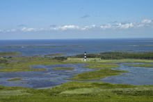
As if to reward them, the postwar years saw a steady flow of Federal dollars to the Banks, and they were spared Reconstruction. Navigational improvements had become unavoidable, and three fine new lighthouses (Currituck Beach, Bodie Island and Hatteras) were built between 1870 and 1875. These provided employment to locals as lighthouse keepers and assistants and a flow of something new to these bare islands – cash. Seven stations of the U.S. Life-saving Service were also built along the coast from the Virginia border to Cape Point, Hatteras.
Outer Banks History – Boom Times
Changes were taking place in the Banks' internal economy as well. Nags Head was becoming the area's first and finest summer resort. Commercial fishing and wildfowl hunting replaced wrecking and whale oil as sources of income.
The 20th century, destined finally to end the fabled isolation of these low, remote islands, began with a symbolic event: the arrival of the brothers Wright. The history of their failures and their final success is probably the best-known story of the Outer Banks, though the Lost Colony must run a close second.
The boom years began in 1930-31. The rest of the country was in a depression, true, but these years marked the completion of the first road accesses to the beach, the Wright Memorial Bridge across Currituck Sound to Kitty Hawk and the Washington Baum Bridge from Roanoke Island to Nags Head. Paved roads down the islands followed, and development began.
Another milestone was passed in the late 30s when the federal government decided to “save” the Banks. Six Civilian Conservation Corps camps were established, and millions of dollars were spent erecting sand fences and planting sand-binding vegetation along 115 miles of shoreline. The Cape Hatteras National Seashore was officially established in 1953 and now controls most of the land from Whalebone Junction down to Ocracoke Inlet, with exemptions for the villages of Rodanthe, Waves, Salvo, Avon, Buxton, Frisco and Hatteras and Ocracoke villages. The National Park Service also administers the other two most popular visitor attractions, the Wright Brothers National Memorial and Fort Raleigh.
World War II saw the Outer Banks' isolation end – with explosions. In 1942 Hatteras abruptly became the war's front line as Hitler's U-boats struck at American merchant shipping. Scores of vessels went down, many in sight of the beach's horrified residents. But the tide turned here, eventually, and the first U-boat sunk by Americans lies a few miles off the beach of Bodie Island.
The postwar period saw two concurrent booms; short-term visitors, attracted by the National Park Service facilities and the sea, and longer- term summer residents. The now-ubiquitous beach cottage, built on piers or posts in case of hurricane flooding, appeared first at Nags Head and has spread steadily north. Until the 1970s, the permanent (winter) population of the area had not changed much since 1900. That population has grown significantly, however, in the past few decades. These permanent residents, many of whom own, run or work in seasonal establishments, derive most of their income from services to visitors, though with the increased local population, many businesses now stay open year round. Boat building and commercial fishing are still important in Hatteras and Wanchese.
These independent, somewhat clannish Outer Bankers deeply love their home islands. It is for the visitor, though, that the Outer Banks seem to have been designed.
For camping, fishing, swimming, wind surfing, SUPing, surfing; for biking, running and golf;.for beachcombing, bird watching and just lying on a fine sand beach in the sun. For vacationing, honeymooning, winding down, taking it easy, dropping out, goofing off. For learning a little American history firsthand. For getting to know the sea and wind again. That's what the Outer Banks are really for.